
The public release of Google Earth in April 2005 kept my family and I huddled around our computer for days, squinting at the screen, my hand on the mouse and my dad hunched over my shoulder.
My family spent nearly four decades in exile not knowing what remained of their lives in Baghdad. Hovering the cursor over the length of Saadoun Street, we zoomed in and out to get our bearings, counting city blocks by memory, and cataloging what was left of the ancestral homes of every family member we could think of. Dad’s house was completely demolished, but aunts and uncles who lived closer to the Masbah, a few blocks south, still had theirs standing.
Two years into the U.S. invasion and occupation of Iraq, this moment of reconnection with the city my family had called home arrived amid another kind of heightened visibility: the haunting familiarity of Baghdad’s streets and building facades in constant loop on the TV a few feet away from our computer.
These images supplanted memories of date palms and river swims with brutal depictions of a new reality: the view of the Tigris through the window at my grandparents’ house was now the very same view through which news cameras showed us pieces of the destroyed Al-Sarafiya bridge floating crosswise downstream. But Google Earth was different; it allowed us to take control of the camera and use it on our own terms.
The technologies that granted us this portal back to Iraq, however, were the very same tools aiding in its capture and broadcasting its destruction.
***
Google Earth’s interface traces its development back to a company called Keyhole, a 2001 offshoot of a computer graphics software company that sold a product called EarthViewer, which stitched together satellite imagery into one comprehensive worldview.
“It was a terrible time for start-ups: 2001, 2002 was right after the dot-com crash,” Keyhole’s VP of engineering, Brian McClendon, told me. “Raising money and so forth was nearly impossible.”
The months leading up to the March 2003 Iraq invasion completely altered the course of Keyhole's future as they secured agreements with a vital set of new clients. EarthViewer found itself at a unique intersection of profitability: it was both a tool for supporting U.S. military operations and a tool for documenting the military incursion through mass media.
In February of 2003, Keyhole secured a sizable investment from In-Q-Tel, a nonprofit venture-capital firm funded by the CIA, after successful trials of the technology within various Department of Defense agencies. According to In-Q-Tel’s own records, Keyhole’s tools aided the U.S. invasion from the beginning.
“Within two weeks of In-Q-Tel's engagement with Keyhole, we implemented the technology to support our mission within the Pentagon," said the National Imagery and Mapping Agency (NIMA)’s Rob Zitz in a press release from In-Q-Tel dated June 2003.
According to McClendon, the Department of Defense primarily used EarthViewer for “previsualization” of military zones—to sketch out, analyze, and rehearse potential operations before execution—as the maps were not accurate enough to locate individual targets. But Keyhole’s founders were surprised to find that soldiers out in the field were using it, too.
“In one anonymous voice mail left for the company after hours, an ‘operator’ had called to say thank you,” wrote Keyhole’s marketing director Bill Killday in his book Never Lost Again. “He and his team had come under fire and needed to figure out a way to safety. Deep in enemy territory, they had resorted to EarthViewer, connected via a satellite data connection. With new insight into their location and the surrounding environment, they had been able to find a way out.
“As perverse as it sounds, the invasion of Iraq proved to be a turning point for Keyhole—a huge cash injection when we needed it most,” Kilday wrote.
Keyhole’s wins compounded when the company brokered a deal at the start of 2003 with CNN to use satellite maps in their news broadcasts. On the night of March 20, during the broadcast of the U.S. invasion of Iraq, CNN anchor Miles O’Brien showed Keyhole’s EarthViewer live on air and drew dotted lines mapping out the expected ground invasion route of American troops into Baghdad.
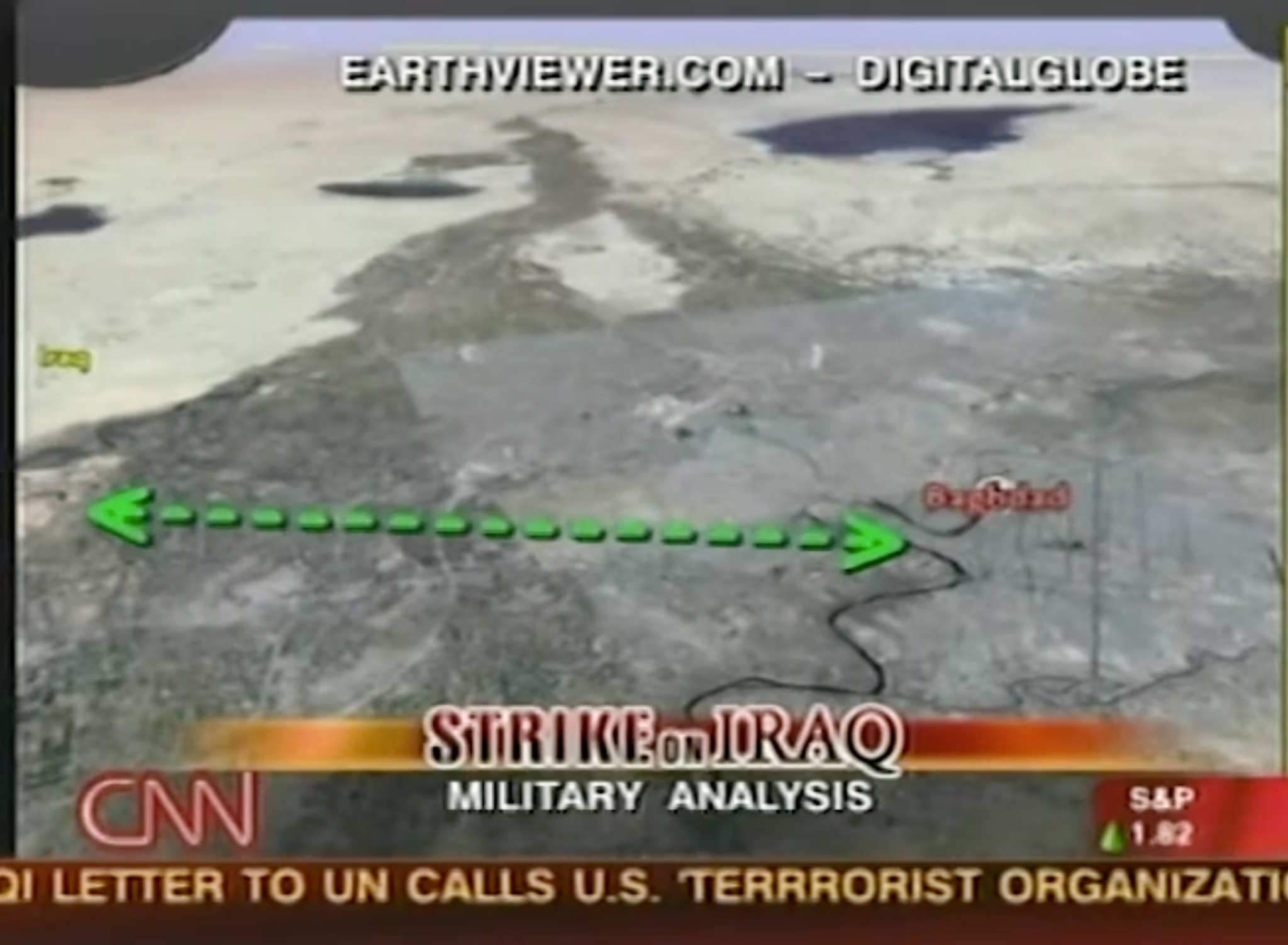
“Suddenly CNN was the center of attention, with Keyhole on the screen for five to ten minutes every hour and…our logo was at the bottom right of the screen [of every broadcast],” McClendon noted. “Everybody started downloading Keyhole. Our servers nearly melted.” Soon after the invasion, ABC and CBS brokered similar deals to use Keyhole in broadcast news programming.
In 2004, a year into Keyhole's skyrocketing success, Google—already the U.S.’s leading search engine—scheduled various meetings with the Keyhole team to discuss their business.
“Twenty-four hours later, they made an offer to buy us,” said McClendon, referencing a key meeting he attended. Google acquired Keyhole and about eight months later released a polished, public version of Keyhole’s mapping technology, called Google Earth.
***
Now, two decades since Google Earth’s public launch, satellite maps have embedded themselves deeper into the media systems that document the world around us, particularly in this moment of escalating global violence.
The first “livestreamed” genocide, the first “AI-driven” war—these terms have come to define the genocide in Gaza and the emerging technologies that facilitated this violence and our ability to bear witness to it. Satellite imagery of real-time war crimes now live within our day-to-day media consumption, disseminated by global media outlets and personal Instagram posts.
“The war in Gaza definitely was a turning point for many journalists and media outlets,” said Kuang Keng Kuek Ser, senior editor at the Pulitzer Center. For Keng, the sheer volume of raw testimony coming out of Gaza was unprecedented. This constant stream of photos, videos, and interviews from Gazans living through the genocide required newsrooms to monitor and interrogate claims on the ground at a faster pace and with greater detail than ever before—a need satellite maps were uniquely positioned to meet.
“The rise of using satellite imagery also really corresponds with the advancement of that technology,” Keng said. Our skies today hold tens of thousands of orbiting satellites, producing imagery with exponentially higher resolution and frequency than those populating Google Earth in the early 2000s. ”We can now do weekly if not daily monitoring.”
Over the past two years, material evidence in these satellite maps has fundamentally altered our collective comprehension of state-sanctioned violence in Gaza and the broader region. Side-by-side aerial comparisons of Gaza neighborhoods, visible bloodstains in satellite images from El-Fasher in Sudan, a grid of freshly dug graves beside the bombed Shajareh Tayyebeh primary school in Minab, Iran—these digital artifacts seem to thwart attempts to obscure the truth around the scale of violence.
“In the beginning of the genocide [in Gaza], Zionists were nitpicking at certain individual posts or videos. When you zoom out, all of that becomes irrelevant,” said Rahma Rashad, a researcher who analyzes satellite maps for the Palestinian Youth Movement (PYM), an international grassroots organization focused on Palestinian liberation. “You can’t get lost in the minutiae when you see how broad and large-scale the destruction has been.”
The perceived narrative power of satellite maps transcends political boundaries between media producers, boundaries that have only grown sharper since the onset of the Gaza genocide. Map-based stories appear as rare moments of alignment between media outlets that otherwise operate in complete opposition, even around the very definition of what occurred in Gaza; Al-Jazeera and Eye on Palestine started referring to the violence in Gaza as a genocide weeks after October 7, while The New York Times sent an internal memo explicitly instructing reporters to avoid the term—publishing op-eds to debate its use months later. PYM still supports a boycott of The New York Times in response to their biased and misleading coverage, which they see as manufacturing consent for Israel’s massacres in Gaza. However, about a year after the onset of the genocide, all these outlets and organizations, including PYM, were sharing similar side-by-side comparisons of Gaza satellite imagery, visibly detailing the flattening of entire neighborhoods.
“In both movement spaces and in legacy media, there’s this effort to try to convey messages using the visual legitimacy that these maps seem to provide, because it’s almost as if these are incontestable,” said Nas Abd Elal, a graphic designer for Visualizing Palestine and a PYM member. “Combined with this racist anti-Palestinian rhetoric, which doesn’t consider these people human, along with the criminalization of Palestinian civil society and research organizations, we see these maps as a tool to make these narrative interventions into an audience that will see them as palatable.”
But why would media outlets that seek to obfuscate narratives about the Gaza genocide share images that so blatantly show the truth? Some argue this may be a larger tactic in decentering the perspective of Palestinians living on the land, reinforcing the legitimacy of a view that only the West has control over.
“If there's a camera hovering above the land, there is a certain legitimacy and authority behind the power that was able to capture this. It's seen as more reliable than witness testimony, even witness testimony in aggregate, which lacks this ‘neutral confirmation,’” Abd Elal said. “[It] can be a bit misleading in terms of understanding how things look for everyday people on the ground.”
Anti-imperialist organizers in other regions echo concerns about how the West responds to these bird’s-eye view images—they may induce outrage without a clear understanding of facts on the ground or historical context, and risk provoking other harmful sentiments, like calls for foreign intervention.
In October 2025, alongside images from Gaza, the world witnessed other genocidal violence through the lenses of satellites. The UAE-backed Rapid Support Forces (RSF) besieged the Sudanese city of El-Fasher, massacring thousands.Western news outlets like NBC, ABC, and The Guardian published satellite maps with visible pools of blood on the land, breaking what many organizers perceived to be a mainstream media silence around the ongoing violence in Sudan.
“While the last 48 hours of footage emerging from Sudan has been some of the most horrific and heartbreaking, the reality of the West’s understanding of this decades long genocide is severely lacking… but not without promise of movement,” reads a post co-authored by the Sudanese Resistance Front on October 31, 2025.
“The fact that it's so concretely visible from the skies, that they literally stained the earth with our blood… you cannot cover your eyes after seeing these satellite images,” said Abdullah, an organizer with the Sudanese Resistance Front and Palaver Collective who requested to use his first name only. Like Abd Elal in the case of maps from Gaza, Abdullah felt that these maps missed the mark of exposing the root causes of the struggle. “What doesn’t get shown [is] the twenty-five million… facing starvation levels because of the United States’ sanctions.”
For Abdullah, the spectacle behind these images and the nuance they omit reminds him of the release of horrific aerial photos from the Darfur region in Sudan in the early to mid-2000s, images often exhibited by a class of Western NGOs calling for U.S. occupation and intervention in the region.
Unlike PYM, the Sudanese Resistance Front chose not to share any of these satellite maps as part of their documentation of the violence in Sudan. Instead, the group doubled down in their political education efforts in Western cities to show the U.S. and UAE’s material investments in the Sudanese genocide, a history that these maps don’t show.
“A lot of people see this situation in Sudan and then they’ll be like … Oh this is trending, let's make some content… they think this struggle alone is some shit that has to happen to the less fortunate rather than viewing themselves as part of a concrete struggle,” Abdullah said.
“Sudan is not a struggle of attention.”
***
Other media workers are wary of the mechanisms that produce these satellite maps in the first place.
“[Satellite maps have] the illusion of total openness, this perspective of the globe that we can now have. On a business level, on a capital level, what does that look like?” says Rowena De Silva, an open source investigator at Airwars. “There is a monopoly of companies that have access to satellite imagery and control the areas that are available for us to have in high definition.”
Only five companies control nearly 60 percent of the collective market share of the satellite imagery industry, according to a 2024 report from Global Market Insights.
Vantor, historically known as Maxar Intelligence, leads the market through longstanding agreements with the same Department of Defense agencies that worked with Keyhole—such as the National Geospatial-Intelligence Agency. Last year, Vantor was awarded over $200 million to “help accelerate sovereign defense and intelligence capabilities and space leadership across the Middle East and Africa (MEA),” according to their press release.
Planet Labs ranks third in the market, but leads the industry in the number of imaging satellites it operates in space—around two hundred in orbit, compared with Vantor’s ten. While Planet Labs also holds defense contracts in the U.S. and abroad, the vast coverage area of their large satellite fleet makes them a particularly appealing vendor for newsrooms; The New York Times is one of their key media clients.
Both Vantor and Planet Labs offer a service called satellite tasking. Premium users can “task” specific satellites in space to zoom over a location during their orbit and capture live, high-resolution imagery on demand. Vantor and Planet Labs users can task a particular location between ten and fifteen times per day, garnering imagery as fine as 30 centimeters per pixel—which is powerful enough to identify vehicles, building details, and the movement of large groups of people. Satellite tasking is a crucial and virtually unreplicated tool in many investigative contexts: surveilling the state of a building from hour to hour for forensic analysis, or tracking large vehicles—like cargo ships—from one location to another in real time.
A subscription for these services at either company costs between $10,000 and $40,000 annually for an individual account, with enterprise agreements costing millions. And having the money to pay for a subscription does not guarantee access to the imagery you’re looking for.
Planet Labs “heavily restricted and obscured parts of images over the Gaza Strip” during the onset of the genocide in 2023, with users noting delayed access or “large solid-color blocks” over regions of Gaza, according to a report by Semafor. Planet Labs never officially disclosed the extent of these restrictions, but the company has since implemented much broader and more explicit constraints on satellite access in response to U.S.-backed military activity.
On March 9, 2026, about a week into the U.S.’s war on Iran, Planet Labs announced a blanket fourteen-day delay on satellite imagery access to an “Area of Interest” covering most of the Middle East, a move “to ensure our imagery is not tactically leveraged by adversarial actors to target allied and NATO-partner personnel and civilians.” These restrictions came within the same week that many news outlets used Planet’s own satellite maps to expose the killing of over one hundred schoolchildren in Minab, Iran, by a U.S. missile strike.
As President Trump escalated threats of mass violence against Iranian civil infrastructure, Planet Labs subsequently expanded their data delay at the U.S. government’s request into an “indefinite withold[ing]” of all new and historical imagery from the entire region, expected “to last through the end of the conflict,” according to an April email to customers.
The Semafor report also alleged that both Planet and Vantor delayed newsroom access to Gaza imagery after October 7, a claim the Vantor team denied in a response to my request for a comment. However, the company openly discloses their “rigorous controls in place for imagery of areas where U.S. military or allied/partner forces are actively operating, including limiting who can task new imagery or purchase historical imagery,” Vantor Senior Director of Communications Tomi Maxted told me.
As with the proliferation of many major technical innovations—the internet, social media, generative AI, to name a few—the immense, concentrated power that these companies offer through their products creates what can most accurately be described as a private government.
We see this phenomenon play out with Planet Labs and Vantor, whose one-off restrictions on satellite maps are a small part of a larger system of rules that determine who can access these images. Acacia spoke to an employee at Planet Labs, who described the functions of an internal governing body that litigates access to their satellite mapping privileges. Called the “Ethics Committee,” this group of employees flags potential instances where clients may be using Planet Labs imagery for questionable or malicious purposes, and can submit formal recommendations to the executive team to deny certain sales requests or even cancel contracts altogether.
What defines a questionable or malicious project remains a debated question among a diverse and often divided pool of internal staff. “There’s always going to be a tension between different parts of the company. We have a lot of veterans and so they feel very strongly about being able to support defense-type use cases. And then you have a whole sector of the company that’s very against it,” said a senior Planet Labs employee who chose to remain anonymous, noting that these defense contracts remain a core part of Planet Labs' business model. “The reality of the market is that the money to be able to be a functioning company comes from the government space,” they said.
Vantor operates a similar kind of ethics committee, which holds the power to approve or deny contracts for entire governments. “We only work with countries that meet an ethical baseline,” explained Maxted. “We have a committee that meets regularly to evaluate and update the list of countries we do not sell to.”
With the exorbitant cost of satellite vendor subscriptions, ambiguous and ever-changing security and political restrictions, and consolidation of the market in the U.S. and Western world, journalists and researchers in the Global South rely on luck—and the discretion of those in control—to conduct the same investigations that large enterprise newsrooms in the West can do with ease.
Keng worked on a project investigating oil shipments between Iran and Russia and was able to identify suspect vessels from archived aerial images, but without access to a Planet Labs tasking subscription, his team had to hope that some full-access clients were taking snapshots of the areas they needed and disseminating their imagery.
“Satellite imaging companies are able to track these ships every day…but for us we can only try our luck to see if there is an image at this point of time at that location that allows us to see if there is any wrongdoing,” Keng said. “There was this discussion among journalists and newsrooms: can we have our own satellites?”
***
Two years into the Gaza genocide, the U.S. and Israel are starting to openly share evidence of their war crimes, the kind of evidence that large-enterprise satellite imagery investigations would uncover. Organizers now need to think beyond that framing to enact the kind of change they want to see.
“There is almost an exhibitionist aspect of the Israeli military: ‘We're going to bomb these houses and post them on TikTok.’ [And] you now see the U.S. openly posting videos of their drone strikes on fishermen in the Caribbean,” Abd Elal said. “There’s this notion that if you expose some war crime that’s happening, that will sort of direct some change. But that’s not the world we’re living in now. There is this sense of impunity that [Israel and the U.S.] can get away with [it], even if the evidence is found. In fact, them explicitly exposing this evidence is an attempt to highlight how little it will matter.”
Rashad, Abd Elal, and De Silva all conduct investigations without a premium subscription to a satellite vendor, relying on archival imagery they can source through the internet in tandem with a variety of other forms of evidence they have to find on their own.
.jpg)
In October 2024, De Silva’s research firm Airwars and Sky News published The Killings They Tweeted, a forensic report that used satellite maps to geolocate seventeen videos of airstrikes posted by IOF soldiers on social media, further verifying allegations of hundreds of civilian casualties.
“Nearly all technology is born from a military purpose,” says De Silva, “[but] if we treat these images the way we treat photos and videos, in that genealogy, they become useful.”
The Mask Off Maersk campaign, a collaboration by Rashad, Abd Elal and other PYM researchers and analysts, utilized satellite imagery to trace weapons transfers to occupied Palestine and the ports where vessels docked.
.jpg)
Without on-demand satellite data, the team at PYM relied on a variety of sources to identify ships in question: shipping contract documentation, vessel transponder signal data, and recorded changes to ship draught — the measured depth of the vessel below water level — which can estimate changes in cargo weight. With this data on hand, satellite image archives helped corroborate the locations of these ships through visual identifiers—shipping containers themselves were visible in archival satellite maps the team could find. Through a published series of forensic reports, PYM’s research led to direct actions that have successfully blocked these ships from docking or loading at various ports in Europe and North America.
”You see in practice how helpful it can be to build an evidence-based research report using the same tools as the military apparatus,” Abd Elal said. “Why would we deny ourselves these tools to mount these sorts of campaigns that have led to real shifts, real changes? It’s ground that, as a movement, you don’t want to cede.”